Fall is coming! It will soon be time to get out and enjoy the autumn weather – or to find an historic road to follow.
And there is one going right through Eau Claire. The Yellowstone Trail, a coast-to-coast 104-year-old national treasure, runs from “Plymouth Rock to Puget Sound,” as its motto reads.
When it all began in the early 20th century, long-distance roads (called trails) were dirt or gravel; railroads got all of the attention from Congress and state capitols. Indeed, most state constitutions even prohibited “internal improvements” like roads.
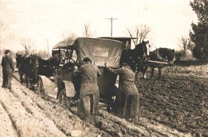
A pleasant Sunday afternoon on the Yellowstone Trail. (Authors’ collection)
Roads were abysmal, mud and sticky gumbo in wet weather, dusty in dry. Counties and townships had to struggle alone to raise funds for roads. In the unique style of Americans, private organizations emerged to push counties to build “their” road and to get tourists to travel it for their towns’ economic success.
The Yellowstone Trail Association, begun in South Dakota in 1912, created the first transcontinental route (trail) in the northern United States. Step by step, the group persuaded counties to build better roads that connected to roads in the next county, and as this happened, the Association placed its signs along those roads.
The Association soon became successful in western states. Membership quickly grew to 8,000 and towns fought to get on the trail. With few roads in the West, the Association, persistently shoving county boards to build roads, was viewed as a god-send.
The East was a different story. There, many short trails already existed. Roads were named: Albany to Buffalo, Ridge Road Cleveland to Toledo, Boston to Albany trail, and many others.
So many trails existed that the Yellowstone Trail Association was refused the right to put its signs along the popular Lake Erie route in New York. Eleven other trails had already claimed that route.
Eventually the Association did mark an eastern route, but there was no organized booster support. So the Association became a tourist agency with bureaus sending tourists west along “its” trail.
After 1927 – when main roads across the country were given U.S. route numbers – the 3,600 miles of the Yellowstone Trail became designated on 25 state roads, 14 federal highways, two Interstate highways and innumerable county roads.
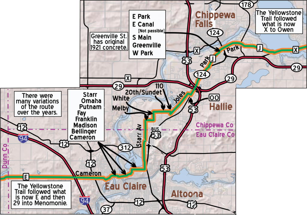
Map prepared by John Ridge
The 1915 route came in from the west on what is now County Highway E to Cameron Street, crossed the Chippewa River on Madison Street, then continued on to East Madison, Putnam and Omaha Streets.
It turned left onto Starr Avenue and went north, exiting Eau Claire proper at Melby Street on its way to Chippewa Falls and ultimately to the east coast. You can see yellow signs with black arrows along this route today, courtesy of Visit Eau Claire and the modern Yellowstone Trail Association.
What can you see along the trail in this area? The most visible relics of the early 20th century along the Trail are the Amber Inn Bar and Grill at 840 E. Madison St. and the Livery Stable Restaurant at 316 Wisconsin St., one block south of Madison Street.
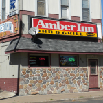
The Amber Inn as it appears today. (Authors’ collection)
The Amber Inn building is 130 years old and the Stable is 123. Each of these buildings could have been used by Trail travelers, as the Livery morphed into an auto repair shop before becoming a restaurant.
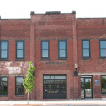
Modern view of the Livery Stable restaurant. (Authors’ collection)
Look north from the present Lazy Monk Brewery across W. Madison Street and imagine a large cannery building there. The new Cannery redevelopment area is going to be built along the river there. On this land the Lange Cannery was built in 1900 and functioned until 1946 when it was sold to the firm now known as National Presto Industries.
We hope you will enjoy traveling along the Yellowstone Trail in the Chippewa Valley.